-
 It's expecting even fewer named storms compared to its last forecast in June.
 -
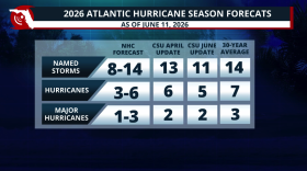 Colorado State lowers its 2026 hurricane season forecast due to a strong El Niño developing during the season. What does this mean?
 -
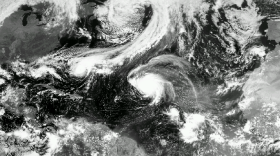
 In Florida, the forecast cone is only part of the story. Hurricane impacts can extend far beyond the center track — reaching inland through wind, flooding, and tornadoes.
 -
 From what El Niño forecasting means to documents to have on hand during an emergency, here are some things to know at the start of the 2026 hurricane season.
 -
 NOAA’s outlook for the 2026 Atlantic hurricane season predicts below-normal activity as an impending El Niño will lead to increased wind shear across the basin.
 -
 With hurricane season approaching, the National Hurricane Center is preparing to test a new forecast cone and mobile-friendly web pages. Meanwhile, the Trump administration has again proposed eliminating offices that investigate hurricanes and improve forecasts.
 -
 The forecast cone shows the likely path of a storm’s center—but in Florida, dangerous impacts often extend far beyond it.
 -
 The first named cyclone in the Atlantic basin typically forms around June 20, with meteorologists tracking the first hurricane by Aug. 11. The first named storm will be Arthur.
 -
 A developing El Niño could affect Florida in two major ways: fewer Atlantic hurricanes, followed by a wetter, stormier winter with greater severe weather risk. NOAA says El Niño over a 60% chance of developing in summer 2026, with a 1-in-3 chance of becoming strong by late fall.
 -
 Forecasters expect tropical cyclone activity could resemble seasons in 2006, 2009, 2015 and 2023. El Nino plays a prominent role in each of the seasons.
 -
 La Niña officially emerged in September 2025 and lasted until April. Neutral conditions are present, but an El Niño is expected to emerge later in 2026.
 -
 Colorado State University is one of the most highly revered names in hurricane forecasting, and for Florida, that matters. Here’s why a landlocked university has become so influential for a state that sees more hurricane hits than any other.

© 2026 All Rights reserved WUSF
Play Live Radio
Next Up:
0:00
0:00
Available On Air Stations


