A disturbed area of weather that the National Hurricane Center has given a low chance of developing off the east coast will raise concerns for localized flooding and prolong dangerous marine conditions through the weekend and into early next week.
The combination of a ridge of high pressure over the northeast U.S., a stationary boundary and a developing area of low pressure will keep much of the eastern half of the state under squally conditions.
Forecast models indicate the heaviest rain will fall east of Interstate 95, where 3 to 6 inches could accumulate through early next week. Areas between I-75 and I-95 may receive around 1 to 3 inches, while regions west of I-75, including much of the Panhandle, are expected to see lighter rainfall amounts over the next several days.

Where bands of rain train over the same areas, rainfall could be even higher, quickly overwhelming drainage systems and causing flash flooding.
Florida’s Space Coast appears to be in store for some of the heaviest precipitation, with some forecast models indicating near double-digit rainfall totals by the start of next week.
Most thunderstorms that develop are expected to remain below severe weather criteria, though an isolated waterspout or tornado cannot be ruled out.
The rainfall means that visitors to events such as Halloween Horror Nights in Orlando and "Monday Night Football" in Jacksonville may want to pack a poncho.
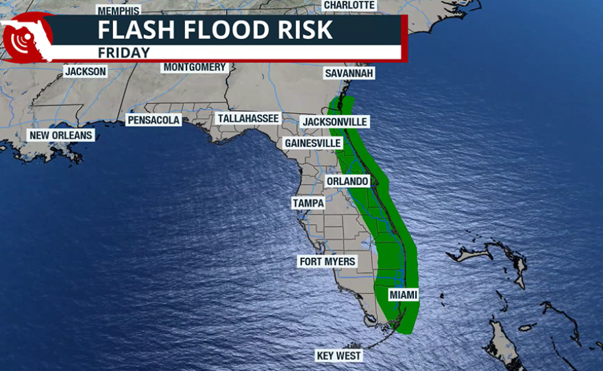
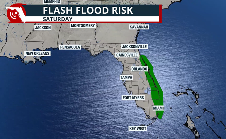
NOAA’s Weather Prediction Center has highlighted Florida’s east coast each day over the next five days for the potential of excessive rainfall, which could lead to localized flooding.
So far, the chance of heavy rainfall has not triggered the issuance of any inland flood watches, but a coastal flood watch has been issued along waterways and beaches in Northeast Florida, as water levels remain high following Hurricane Imelda.
In addition to the rainfall, winds east of I-95 are expected to be breezy, in the range of 15–25 mph, with gusts as high as 35 mph along the immediate beaches.
All the motion in the ocean has resulted in rough seas and dangerous rip currents, a threat that will likely continue for the next week.
The NHC has given the disturbed area of weather off of Florida only a 10% chance of developing over the next seven days.

Forecasters are also watching a tropical disturbance that has yet to emerge off the coast of Africa, which actually has a slightly higher chance of developing over the next week.
The eastern Atlantic disturbance will not be a threat to any landmasses over the seven days, as it slowly works west and is expected to remain east of the Caribbean islands beyond the timeframe.