-
 Florida's meteorological summer is at its halfway point. So far, the 2026 season has produced above-average warmth and varying amounts of precipitation.
 -
 Saharan dust is in place, and a high pressure will continue to bring dangerous heat across much of Florida throughout the weekend. Several records were either tied or broken on Thursday.
 -
 Florida finished June as one of its 10 warmest on record despite cooler conditions in parts of the state. Forecasters are now tracking another prolonged stretch of dangerous heat.
 -
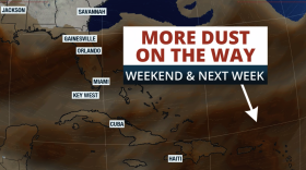
 A plume of Saharan dust is set to arrive to Florida, causing the storm chances to drop and temperatures to soar. Let's talk about the dust!
 -
 A weak area of low pressure is meandering off the Southeast. Florida beaches could still see heightened surf and an increased risk of rip currents through the July 4th holiday.
 -
 Drought conditions are improving across many areas in Florida, but temperatures are about to soar, and chances of storms become more limited this weekend. Also, Saharan dust could be making the skies hazy.
 -
 A stationary front increases rain coverage across parts of Florida through the end of this week, while a high-pressure system builds just in time for the weekend, bringing temperatures near record heat or breaking records.
 -
 Florida officially entered astronomical summer on June 21, marking the longest day of the year.
 -
 On Thursday, temperatures were already hot across much of the Florida Peninsula, with roughly two-thirds of the state under a Heat Advisory. Not only were air temperatures high, but the combination of heat and humidity pushed heat index values as high as 110°F in some locations.
 -
 Florida is known for its sunshine and heat, but the state’s hottest air temperature is actually lower than nearly every other state.
 -
 Our morning summer temperatures are running about eight to 10 degrees above average, while nighttime is warming almost twice as fast as daytime across the country.
 -
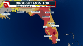 The exceptional drought has been cut in half! But not all rain has been accounted for in this drought report.

© 2026 All Rights reserved WUSF
Play Live Radio
Next Up:
0:00
0:00
Available On Air Stations


