-
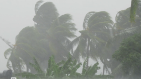
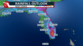 Days of rain across Florida as tropical moisture arrives and increases the flood threat.
 -
 Florida’s rainy season doesn’t begin all at once, and it doesn’t behave the same way all summer. It tends to build across the state, then shift through three distinct phases.
 -
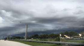 The weather pattern changes in Florida as the rainy season starts. Rain is needed and welcomed.
 -
 The restrictions apply to all residents, even those with private wells. Starting April 17, citations can be issued without warning. A Phase Three Extreme Water Shortage has been issued.
 -
 Eustis was inundated with 19.7 inches of rain, Mount Dora had 17.76 inches, while Port Saint John saw 15.57 inches, according to a 24-hour rainfall analysis by the National Weather Service.
 -
 Is this for Florida's rainy season? There are still areas dealing with a worsening drought, which could mean bad news for the coming dry months and wildfires.
 -
 More fake lawns may be coming to your neighborhood. From the front yards of West Miami-Dade to the waterfront mansions of Fort Lauderdale, artificial turf is appearing more and more.
 -
 The summer of 2024 was extremely hot and drought-free. The summer of 2025 has been hot, and a severe drought has affected over 6 million people in southeastern Florida. What changed this year?
 -
 With an 80% chance of showers and storms forecast for the Tampa Bay region and beyond ahead of this Fourth of July holiday weekend, one meteorologist says “when thunder roars, go indoors.”
 -
 Florida's recent rains have significantly reduced the drought, with about 87% now experiencing drought, down from 93%. The calendar also marks the official start of the rainy season for South Florida.
 -
 Some isolated spots received slight relief from the drought courtesy of the low pressure that dissected the state earlier this week. Can we expect more soon?
 -
 Florida received a fair coating of rain on Monday with that low-pressure system that dissected the state. Many received around 2 inches, while the Keys flooded. This could put a dent in the drought.

© 2026 All Rights reserved WUSF
Play Live Radio
Next Up:
0:00
0:00
Available On Air Stations


