-
 Florida has embraced the Trump administration’s aggressive stance on immigration enforcement. But what happens when residents push back and ask local elected leaders to take a stand against it?
 -
 Farm stands have become a unique way for consumers to buy homemade baked goods, fresh eggs and handcrafted items.
 -
 A Tampa resident shares about evacuating ahead of a storm to keep costly insulin refrigerated, and a St. Petersburg resident reflects on her displacement during Hurricane Katrina as a teen in New Orleans.
 -
 Our series of hurricane prep programs covers legal questions and important home documents. How do you pick up the pieces after the storm is gone?
 -
 Whether you’re a longtime Floridian or a newbie to this hurricane business, preparing for storm season can be quite intimidating. Our expert panel has some answers.
 -
 With the elimination of property taxes still on tap in Tallahassee, a study shows billions of dollars in potential losses, with some counties standing to lose more than others.
 -
 Some tree pollen levels are in the high range as Florida experiences its winter and early spring allergy seasons. Juniper, elm and maple trees are active across the peninsula.
 -
 Florida’s 2025 weather was relatively subdued, with no hurricane landfalls and roughly half the usual number of severe weather reports.
 -
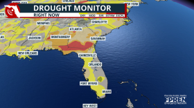 Several Florida counties, including Sarasota and Manatee, are under burn bans as more than 70% of the state experiences unusually dry conditions.
 -
 The 185-mph winds that Melissa packed on landfall made it the most powerful recorded hurricane to ever hit Jamaica — challenging the mettle of the island's most storm-hardened denizens.
 -
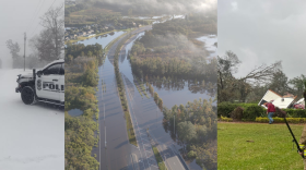
 Eustis was inundated with 19.7 inches of rain, Mount Dora had 17.76 inches, while Port Saint John saw 15.57 inches, according to a 24-hour rainfall analysis by the National Weather Service.
 -
 Tropical storm watches were discontinued, but choppy seas, 12-foot waves and a rip current risk are forecast for the the state's Atlantic coast, with incoming rounds of rain.

© 2026 All Rights reserved WUSF
Play Live Radio
Next Up:
0:00
0:00
Available On Air Stations


