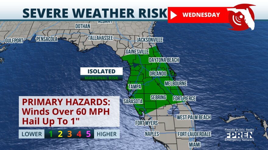
A day after some intense storms rolled through north and central Florida, unstable weather continued Wednesday. Several impulses of energy in the upper levels of the atmosphere were driving the bad weather.
On Wednesday afternoon, the line of storms will likely affect the Tampa Bay area and parts of Southwest Florida between noon and 4 p.m.
In fact, a severe thunderstorm warning remains in effect until 5 p.m. Wednesday for Citrus, Hernando, Hillsborough, Manatee, Pasco, Pinellas and Polk counties.
The stormy pattern is courtesy of the next cold front that lacks cold characteristics but will bring plenty of instability to produce the chance for severe weather,
A tornado watch for much of Central Florida expired at 11 a.m. Wednesday.
Flood threat
Severe weather moved across parts of North Florida triggering several severe thunderstorm warnings and tornado warnings during the morning on Tuesday. Rainfall totals in some spots reached between 1 and 2 inches between Pensacola and Tallahassee.
Areas just to the northwest of Orlando, like The Villages, received slightly more than an inch and a half on Tuesday so far. The rest of North and Central Florida reached between a quarter and half an inch.
The ground continues to be well saturated so any rain that falls Wednesday could lead to isolated flooding.
Rain totals across Central Florida will range between 1 to 2 inches and some isolated areas could receive up to 3 inches of rain.
Remember, turn around don’t drown.

The chance for storms diminishes as this line moves over South Florida on Wednesday, but storm chances pick up on Thursday for Miami-Dade, Broward, and Palm Beach counties, especially in the afternoon with the sea breezes likely picking up and instability hanging around.


