

Editor's note: Florida Highway Patrol State Troopers will be closing State Road 29 from Interstate 75 to US 41 on Saturday, February 28, from 9 a.m. to 7 p.m. ONLY local traffic (residents on SR-29) that have not been evacuated will be permitted to enter the area. Florida Forestry Services will be conducting burns along the roadway in preparation of shifting winds in days to come. State Troopers will continue to monitor the visibility conditions along the Interstate 75 corridor. Additional updates will be provided as needed.
Motorists have joined firefighters as an at-risk population during the National Fire, which started Sunday night in the Big Cypress National Preserve and grew to more than 30,000 acres by Friday evening with no containment reported.
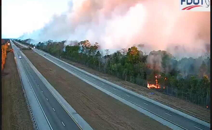
Smoke wafting over Interstate 75, also known as Alligator Alley, forced Florida Highway Patrol troopers to shut down the interstate overnight Wednesday into Thursday.
And now the National Weather Service in Miami is now warning about the possibility of "super fog."
The weather conditions for super fog must be just so: massive amounts of smoke coming from a wildfire with smoldering leaves, marsh grass, and brush, add humid air, and then a drop in temperatures wrings water from the air creating a whiteout similar to a Colorado blizzard — but with smoke and ash from the 30,000-acre National fire replacing snow.
Overnight winds Friday into Saturday, are expected to come from the south, pushing smoke and ash north across Alligator Alley, where it will mix with moisture to create the deadly hazard.
In super fog, drivers often can't see more than 10 feet in front of their vehicles.

The Florida Highway Patrol urges drivers who must travel across the Alley during the early morning hours to slow down and use low-beam headlights, which don't reflect as much light as high-beams.
Super fog is not as well-known a meteorological term as thunderstorms or hurricanes, but the thick, white fog is often just as deadly. In October 2023, a similar mix of marsh fire smoke and morning fog in Louisiana caused a 158-vehicle pileup on Interstate 55 that killed eight people and injured more than 60.
The threat to motorists from various types of smoke and fog this week is so significant that a public safety advisory has been issued to warn the thousands of motorists traveling through the area to be very careful, drive slowly, and watch for fire trucks and other equipment on the road, as well as individual firefighters.
If visibility drops to that level, expect agencies like the Florida Highway Patrol to close the sections of roadway again until things improve.
"We are expecting some potential smoke impacts along the roadways there," Riki Hoopes, a spokeswoman for the firefighters, said earlier this week. "We urge drivers to please use caution when in the area and acknowledge that it may be slow, there may be periodic stops."
According to the National Interagency Fire Center, 154 firefighters are working the blaze from several states, with 14 firefighting engines, 3 water tenders, 4 helicopters, and 3 single engine airtankers. The cost of battling the wildfire has risen now to $1.2 million. The fire was discovered early Sunday morning and grew larger quickly.


The massive blaze is feeding on heavy brush turned to kindling by past hurricanes and a string of brutal freezes this winter that killed off vegetation across the Everglades.
A U.S. Forest Service researcher coined the term "super fog" several decades ago to distinguish the smoke-driven whiteout from a standard morning mist.
Because Florida and Louisiana have abundant wetlands, high humidity, and frequent controlled burns and wildfires, super fog happens here and there more frequently than in any other two states in the country.
The 2008 Interstate 4 Pileup: In January 2008, smoke from a prescribed burn in Polk County mixed with morning fog. The resulting super fog caused a 70-vehicle pileup that killed five people.
The 2012 Interstate 75 Pileup: In January 2012, smoke from a brush fire at Paynes Prairie Preserve State Park mixed with heavy fog near Gainesville, causing a series of crashes that involved 25 vehicles and killed 11 people.
That larger National Fire is just south of Alligator Alley in the Big Cypress National Preserve near Ochopee, as firefighters attacked the blaze on the ground and from the air.
Hoopes said a significant portion of the acreage that increased the size of the wildfire is from land scorched in the perimeter operation earlier in the firefighting effort along Turner Road, S.R. 29, and Interstate 75, also known as Alligator Alley.
"Most of the acreage gained was from defensive burns overnight to keep the fire from hitting the road hard," she said. "This will help eliminate the fuel along the road, so when the fire hits, it will give it a buffer."
Hoopes said no structures have been damaged and no firefighters have been hurt.

For context, this National Fire has already surpassed the Sandy Fire that burned through the same area three years ago. That blaze blackened nearly 20,000 acres, shutting down U.S. 41 and blanketing the region in smoke.
Even though the Sandy Fire burned the same area, it left behind plenty of fuel.
"It's an exceptionally dry year," Hoopes said. "We haven't had any precipitation in months, so it's not unusual to see fires spread in a couple year's growth like that,"
An update from the National Parks Service and the Southern Area Incident Command for the U.S. Wildland Fire Service said area weather and environmental conditions are contributing to the rapid spread and difficulty of containing and extinguishing the National Fire. Factors include lack of rainfall, ongoing Stage 3 drought, frost kill of some vegetation, La Nina conditions, and multiple cold fronts with north winds. Elevated fire weather conditions are expected to continue.
Additionally, the National Park Service amended the area closure for a portion of Big Cypress National Preserve Friday night as follows: Closure includes all areas within the perimeter and the perimeter trails south of I-75, east of SR 29, north US41 (from SR29 west to Turner River Rd), North of Windmill Tram (from Turner River Road west to Concho Billie Trail) (*) (increase from Windmill Tram Road), west of TRU 2, North Concho Billie Trail, Concho Billie Trail.
The closure area was reduced Thursday with the Burns Lake Campground reopening for reservations and day use. Additional closure information is available in the Alerts section of the Big Cypress National Preserve website: https://www.nps.gov/bicy/index.htm
There is also a Temporary Flight Restriction (TFR) in effect over the fire area. The public is asked not to fly any type of aircraft, including drones, near the fire area. Unauthorized drone (UAS) flights pose serious risks to the effectiveness of firefighting operations. Aerial firefighting is suspended when unauthorized UAS are in the area, allowing wildfires to grow larger.
A second brush fire, just to the north of Alligator Alley, was kept to under 5 acres.
A Red Flag Warning had been issued for the Everglades earlier Monday as cold, dry air swept south down the Florida Peninsula over Sunday night into Monday morning.
Early last weekend, wildland firefighting agencies sounded alarms about the wildfire potential for Monday. Hoopes said the flames were first seen Sunday night coming from the National Fire, the bigger of the two then and now.
Forest firefighters have been dreading Florida's spring wildfire season for months as a drought has blanketed much of South and western Florida for a year.
Hoopes said no homes or residents were in danger Thursday night, but some of the back roads within the Big Cypress were closed so firefighters on the ground could work.
Days before the forecast of super fog was made The FHP issued the following notice:
Troopers continue to monitor ongoing wildfire conditions along Interstate 75 (Alligator Alley between mile markers 65–85) in Collier County.
Motorists traveling through the area are urged to use caution, reduce speed, and remain alert for changing conditions.
- DRIVE WITH LIGHTS on low beam. High beams will only be reflected off the fog and impair visibility even more. Your lights help other drivers see your vehicle, so be sure they all work. Keep your windshield and headlights clean, to reduce the glare and increase visibility.
- SLOW DOWN and watch your speedometer before you enter a patch of fog.
- WATCH OUT for slow-moving or stopped vehicles. Open you window a little and listen for traffic you cannot see.
- REDUCE THE DISTRACTIONS in your vehicle. Turn off the radio and keep your cell phone down. Your full attention is required.
- USE WIPERS AND DEFROSTERS for maximum visibility. Sometimes it is difficult to determine if poor visibility is due to fog or moisture on the windshield.
- USE THE RIGHT EDGE of the road or painted road markings as a guide.
- BE PATIENT avoid passing and/or changing lanes.
- SIGNAL TURNS well in advance and brake early as you approach a stop.
WGCU is your trusted source for news and information in Southwest Florida. We are a nonprofit public service, and your support is more critical than ever. Keep public media strong and donate now. Thank you.
Copyright 2026 WGCU

