

Labor Day weekend, the unofficial end of summer, has arrived. Florida will remain under a Marginal Risk (Level 1 of 4) for flash flooding through much of the holiday weekend, as plenty of moisture remains in the atmosphere. Winds will also help keep rain chances elevated across the state. Some locations could even see showers in the morning, while thunderstorm chances will increase each afternoon as sea breezes develop in the heat. Here's a closer look at the forecast across Florida.
Florida will see lots of tropical moisture this weekend. This will translate to afternoon storms and the continued flash flood risk throughout the holiday weekend. pic.twitter.com/5Kwk6Ommzm
— Florida Public Radio Emergency Network (FPREN) (@FloridaStorms) September 4, 2026
Florida Panhandle
Rain chances will remain between 60% and 70% throughout the weekend across much of the Panhandle. A high-pressure system centered over South Florida will keep winds mainly coming in from the Gulf, allowing sea breezes to develop with daytime heating. Numerous showers and thunderstorms are expected to develop mainly after noon.
The mornings could also be soggy, with patchy fog reducing visibility to less than half a mile late at night into the early morning. Any fog that develops will dissipate shortly after sunrise.
This pattern will continue Saturday and Sunday. By Sunday afternoon, a cold front will begin approaching North Florida, keeping plenty of instability in place through Labor Day. As a result, numerous showers and thunderstorms will continue across much of the Panhandle, with storms possible from late morning into the afternoon.
If you have outdoor plans, be sure you have access to a sturdy shelter, as frequent lightning will accompany many of these storms.
Weekend rainfall totals are expected to range from 1 to 2 inches. However, the ground is already saturated from recent rainfall, so any storms that produce heavy rain in a short period could quickly lead to localized flooding.

North Florida
The same high-pressure system over South Florida will keep winds mainly from the southwest across North Florida. A few isolated showers will be possible Saturday morning before the sea breeze develops. During the afternoon, showers and thunderstorms will mainly focus near the I-95 corridor, especially around Jacksonville.
Cities such as Gainesville could also see a passing shower, but activity will remain isolated, as the prevailing winds should keep most storms east of the city toward the Northeast Coast. A similar pattern will continue Sunday and Monday, with about a 20% chance of an isolated afternoon thunderstorm each day.
Temperatures will remain hot. With more sunshine across the region, a Heat Advisory is in effect Saturday as highs climb into the upper 90s, with heat index values reaching 103 degrees. Sunday will remain hot, with highs in the mid-90s and high humidity. Labor Day will be a bit cloudier, keeping temperatures in the mid-to-upper 80s. As the frontal boundary drifts southward, slightly drier air will arrive, making temperatures feel a little more comfortable than in recent days, although skies will likely remain mostly cloudy.

Central Florida
Central Florida will remain active throughout the holiday weekend. Across Tampa, rain and thunderstorm chances will average around 40% each day. Scattered storms will mainly develop after 1 p.m., with most activity focused inland. The Tampa Bay area will see highs in the mid-90s, while heat index values climb to around 105 degrees.
Labor Day brings a better chance for afternoon thunderstorms and increased cloud cover as the front approaches from the north. Even so, highs should still reach the lower 90s before winds shift to the west-northwest Monday night.
For Orlando and the Space Coast, afternoon storms will be more widespread. The east coast sea breeze will develop with daytime heating and push storms inland. Orlando has a 60% to 80% chance of showers and thunderstorms, mainly after 2 p.m. Hot afternoons will continue, with sunny mornings allowing heat index values to reach 105 degrees on Saturday and Sunday.

Labor Day will bring more cloud cover, scattered morning showers, and additional afternoon thunderstorms. The Space Coast will follow a similar pattern, with afternoon storms through the weekend and greater storm coverage on Labor Day.
South Florida
Across Southwest Florida, rain chances will gradually increase through the holiday weekend. Saturday brings about a 40% chance of afternoon thunderstorms. After a mostly sunny morning, highs will reach the lower 90s, while humidity pushes heat index values close to 105 degrees. Winds out of the west-southwest will push much of the afternoon thunderstorm activity inland. By Labor Day, the slowing cold front across North and Central Florida will keep abundant moisture over South Florida, increasing the chance for scattered morning showers followed by numerous afternoon thunderstorms.
Across Southeast Florida, a similar pattern is expected, though this part of the state has the greatest chance of widespread showers and thunderstorms throughout the holiday weekend. Friday's very moist air mass produced gloomy conditions and widespread storms, and that unsettled pattern will continue. Expect mostly cloudy skies with showers and thunderstorms developing late in the morning and continuing into the early evening.
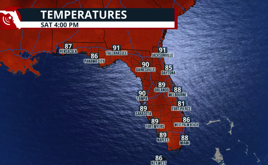
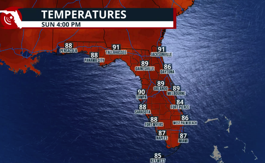
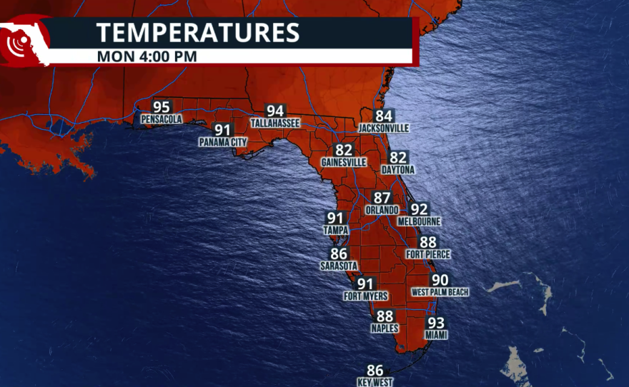
Highs will remain in the lower 90s, but saturated ground means repeated heavy downpours could quickly produce localized flooding. The soggy weather pattern is expected to continue into early next week. Rainfall totals across South Florida are forecast to range from 2 to 4 inches, with isolated locations receiving as much as 5 inches over the holiday weekend.
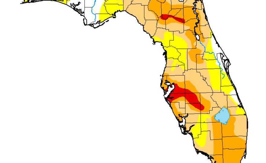
Drought Update
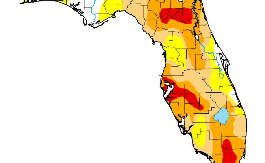
Recent rainfall, especially across interior South Florida, has significantly improved drought conditions. Areas that were classified as Extreme Drought across portions of the Everglades have improved to Severe Drought, including parts of Palm Beach County, much of Broward County, and all of Miami-Dade County.
North Florida has also seen notable improvement. Much of the area previously in Extreme Drought has improved, while large sections that were under Severe Drought are now classified as Moderate Drought. This is encouraging news for two regions that have been dealing with significant rainfall deficits and long-term drought. The good news is that we're still moving in the right direction. Additional rainfall this weekend should further improve drought conditions and keep filling rain gauges across the state.
The next drought update will be released on Thursday and will include all the rainfall that has fallen since last Tuesday afternoon, as well as the rain expected through the holiday weekend.


