

Update: Monday Evening, October 5, 2026
The National Hurricane Center has increased the probability of tropical storm formation associated with an area of low pressure over the western Gulf to a 70% chance within the next 2 days and an 80% chance within the next 7 days.
We are tracking the tropics for the next several days. As of Monday, 10/5 6:49 PM EDT, here is a high chance for tropical development in the Gulf.#TropicalDevelopment #Tropics #Tropical #Florida #Panhandle #GulfCoast #CentralGulfCoast #Coast #FloridaStorms #FPREN pic.twitter.com/cAKcwKlgvZ
— Florida Public Radio Emergency Network (FPREN) (@FloridaStorms) October 5, 2026
As of Monday early evening, the broad area of low pressure is slowly moving east-northeast while battling strong wind shear from the northwest, which will likely displace most of its convection (thunderstorms) to the south and southeast.

As long as the wind shear continues to impact the system, it will limit its ability to strengthen. We will closely monitor the wind shear, as it is forecast to diminish. Once this happens, the system could begin to become better organized and intensify.
Overall, sea surface temperatures across the Gulf of Mexico are running around 1.8°F above average, with temperatures of at least 86°F across the eastern Gulf and as high as 89°F over the western Gulf.
🌀Luckily there will be a lot of wind shear along the northern Gulf Coast later this week, because the Gulf is - by far - the hottest it’s been on record for this time of year. *BUT hot 💧 is only 1 factor, wind shear rules the roost!*
— Jeff Berardelli (@WeatherProf) October 5, 2026
I just did an analysis, and ~40% of the Gulf… pic.twitter.com/HNkasl1O4t
The next name on the list is Isaias.
Let's bring back an oldie from 6 years ago... We could have ISAIAS formed by the end of the week in the western Gulf of Mexico... So here's some help with the name. Thank you for coming to my class. You can Venmo me. 🤣 JK!
— Irene Sans (@irenesans.bsky.social) 2026-10-05T15:29:22.163Z
Original story posted Sunday evening
As we all know, hurricane season has been quiet across the Atlantic Basin. So far, the Atlantic remains on snooze, with no tropical systems currently being monitored. A system could potentially develop later this week over the western Gulf of Mexico. As of Sunday evening, the National Hurricane Center gives this area a 0% chance of development over the next 48 hours and a 40% chance over the next seven days. These percentages will likely increase as the week progresses, especially the short-term probability.
To be extra clear, any development in the Gulf of Mexico will likely remain over this area throughout much of the workweek. Weather models differ on the strength and track of the potential low-pressure system. Keep in mind that, as of Sunday evening, no system exists in the Gulf of Mexico. Therefore, models are projecting a potential system that has not formed yet. Projected tracks could vary widely because, without a well-defined center of circulation, models cannot determine a track with high certainty.
This system, in its early stage, will battle strong north-northwest windshear, which will displace much of the convection southward, and some of the incoming front's energy could catalyze development later this week. We will continue to monitor this closely. For now, we should focus on the flash flood threat that will be present and expanding across the Florida Peninsula this week before anything potentially develops in the Gulf of Mexico.
Florida's forecast
The weather has been very active across the Panhandle, with flood watches continuing through at least Monday evening, extending from Pensacola eastward toward Jacksonville. The highest chance of flash flooding will be across the Florida Panhandle. The flood watch in effect across parts of Jacksonville and the northern fringe of North Florida will remain in effect until Monday morning but could be extended later in the day.
10/4/26 Evening UPDATE:
— NWS Tallahassee (@NWSTallahassee) October 4, 2026
The Flood Watch was extended for our forecast area. Widespread rainfall totals of 2 to 4 inches of additional rain is in the forecast through Monday with a few spots seeing up to 6 inches, mainly along the Emerald Coast.#ALwx #FLwx #GAwx pic.twitter.com/7gcnLbkTQG
According to the Weather Prediction Center, the Panhandle is under a slight risk of flash flooding, meaning there is at least a 15% chance of flash flooding within 25 miles of a point. From Tallahassee eastward, there is a marginal risk, meaning there is at least a 5% chance of flash flooding within 25 miles of a point.
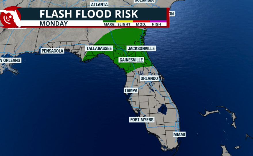
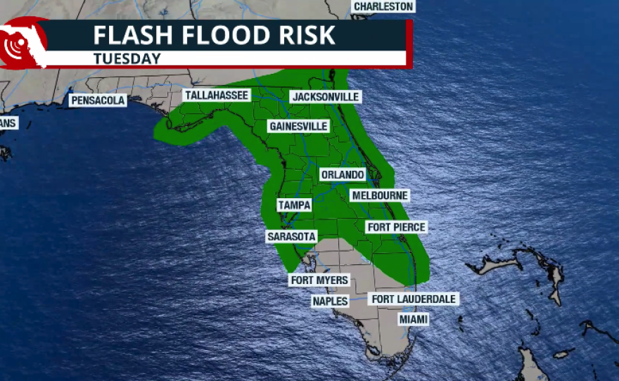
From Monday through Tuesday morning, flash flood risk will continue across portions of the eastern Panhandle and North Florida. As the week progresses, the flash flood risk will extend into Central Florida and parts of South Florida while continuing across portions of Northeast Florida through at least Thursday morning.
-A Flood Watch is in effect from noon today through early Monday morning along and north of I-10
— NWS Jacksonville (@NWSJacksonville) October 4, 2026
-24 hour rainfall totals show generally 2-5" along and north of I-10
-Additional rain of 2-6" is forecast through Wednesday night across the area pic.twitter.com/HsTS9Yq2nN
What is the setup affecting Florida?
Throughout the weekend, a slow-moving cold front—the same front that brought flooding rainfall across Texas toward the end of last week—has continued to push eastward.
Heavy rain has impacted the Panhandle and will continue to slowly spread east and south, covering much of the Florida Peninsula throughout the upcoming week. The issue is that this front will keep moving very slowly and is likely to stall around Lake Okeechobee toward the end of the week.

Rainfall totals
Between Monday morning and Saturday morning, rainfall totals across Florida will likely be most impressive in Northeast Florida. The Jacksonville area could accumulate between 5 and 7 inches of rain, with some isolated locations potentially exceeding 10 inches.
In the Panhandle, not including the rain that fell over the weekend, another 5 inches of rain could fall throughout the week.
Across Central Florida, rainfall totals will generally range between 2 and 4 inches, with some isolated locations—especially where storms become more persistent—potentially exceeding 5 inches.

Across South Florida, Monday will start off mostly nice, with little chance of rain, as it was during this past weekend. Between Tuesday and Saturday morning, rainfall totals will likely be lower but should still range between 1 and 3 inches, though they could exceed 4 inches in some isolated locations. Keep in mind that the front is expected to stall around Lake Okeechobee between Wednesday and Thursday. As a result, there is a greater chance of rainfall and thunderstorms developing across South Florida during the second half of the workweek.


