Several clusters of strong thunderstorms are likely Tuesday, some of which may produce strong or locally damaging wind gusts and torrential downpours.
Heavy thunderstorms dumped about 3 inches of rain over the Pensacola area Monday night in a relatively short period of time, prompting Flash Flood Warnings there. The storms weakened for a time late Monday night but are re-strengthening again Monday morning, where the National Weather Service issued Severe Thunderstorm Warnings in the Tallahassee area.

The storms are likely to strengthen as they move eastward toward Perry, Madison, Live Oak, and Lake City late Monday morning. They are likely to be in the Gainesville and Jacksonville areas during the early or mid afternoon hours.
Additional small clusters of storms could form ahead of the main line as far south as the Nature Coast, but are more likely to concentrate in the center of the peninsula and favor the Atlantic side as the afternoon and early evening goes on.
That means areas like Ocala, The Villages, St. Augustine, Daytona, and Orlando could see strong storms capable of damaging wind gusts later Tuesday afternoon.
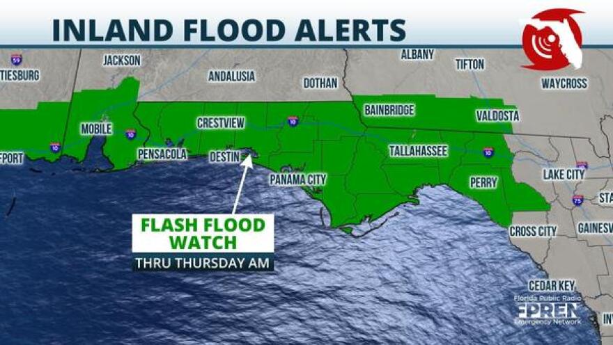
Flash Flood Watches continued for much of the Florida Panhandle, lasting until Tuesday evening over the western Panhandle and until Thursday for the Panama City area eastward to Tallahassee, Perry, and Madison.
Heavy rain from Tropical Storm Claudette over the weekend produced several inches of rain in many areas and more is likely to come this week as a front stalls near the Florida/Georgia state line.

As is often the case in the summer, there is also a chance of scattered showers and storms from the Tampa/St. Pete areas southward toward Fort Myers and Naples. However, data on Tuesday morning suggest the western side of the peninsula are likely to see fewer storms on Tuesday as the prevailing southwest winds push the storms toward the Atlantic side.
Storms developing along sea breezes and lake breezes are also expected from the Treasure Coast to parts of the Florida Heartland, near Lake Okeechobee. A few of these storms could produce strong winds or hail, but they're likely to be fewer in number than storms farther north.
Still, these storms could drift back toward the Gold Coast early Tuesday evening before diminishing.
Copyright 2021 WUFT 89.1. To see more, visit WUFT 89.1.


