


Use this map to search for your evacuation zone in Florida.
A Look Ahead to 2026
-
 Mike Stewart/APFrom what El Niño forecasting means to documents to have on hand during an emergency, here are some things to know at the start of the 2026 hurricane season.
 -
 NOAAForecasters expect tropical cyclone activity could resemble seasons in 2006, 2009, 2015 and 2023. El Nino plays a prominent role in each of the seasons.


Evacuation Zones and Shelter Info


Hurricane season in Florida can be a bit overwhelming, but here are some answers to common questions to help you before, during and after a storm.
Preparation Guide
-
 Mike Stewart/APIn case you lose power, here are different guides you can feel free to download and print out ahead of any hurricanes this season. Just click the link you want and the download or print icon to save it for the future.
 -
 Mohamad Faizal Bin Ramli/Getty Images/iStockphotoThere's a lot to consider when preparing for an approaching storm. Get a head start on hurricane season by arranging your important documents now.


What You Need To Know


-
 The Atlantic hurricane season is entering what is typically the busiest stretch, but an El Niño event is expected to suppress tropical activity.
 -
 In Florida, hurricane vulnerability is shaped not just by the storm, but by the way people live — in high-rises, along waterways, and across coastal communities where power loss, heat, and marine damage can complicate recovery.
 -
 Saharan dust and wind shear are keeping things quieter in the Gulf, but an ocean scientist says, "it only takes one in the wrong place."
 -
 A stationary front and deep moisture in the atmosphere will bring several days of heavy showers and thunderstorms, keeping the threat of flash floods across the northern half of Florida this week.
 -
 The cameras are designed to help scientists better understand how flooding develops, and how communities can prepare for it.
 -
 Hillsborough County officials recommend stocking up on healthy foods, keeping emergency kits ready and having a plan before a hurricane is at the door.
 -
 The El Niño weather pattern could limit how many Atlantic storms form this year. But unusually warm waters temperatures mean the risk of destructive storms is still high.
 -
 Tropical storm watches are in effect from the Panhandle west to Plaquemines Parish, Louisiana, with a storm surge watch extending from the Alabama-Florida border to the mouth of the Mississippi.
 -
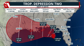 Tropical Depression 2 is set to become Tropical Storm Bertha as it travels mainly due west during the next few days. Gulf waters are warm and could strengthen this system if it stays well away from the Gulf Coast.
 -
 Rounds of heavy rain are expected to affect North and Central Florida this weekend. Here’s what to know about sandbag sites.
 -
 Rounds of heavy rain will impact parts of Central and North Florida due to a potential tropical system. Mixed signals on where it could go and intensity.
 -
 An area of low pressure could develop near Florida within the next 7 days. Could it impact Florida?


